Learning about Iowa's Geology using Google Earth
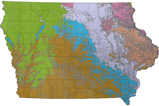
Mouseover Bedrock Map to see Iowa's major fault zones.
1. Create and label a folder on your desktop (or other easily accessible location) to store IGEIN.kmz files.
2. Download the following files to your new IGEIN Folder...
(Right click each file listed below and select SAVE TARGET AS to the IGEIN folder)
Bedrock
Bedrock faults
Sinkholes
MidContinent Rift
MidContinent Rift erosion
Landform regions
Black Hawk County, Rivers
Black Hawk County, Slopes
Des Moines Lobe
3. Open Google Earth on your computer
(If you do not have Google Earth, Please click here to download this amazing and FREE software) You may need to work with your schools IT coordinator to install and use this software.
4. Open the new Iowa data in Google Earth!
File > Open > SELECT FILE FROM YOUR COMPUTER
Importing these geologic layers to Google Earth - to your Iphone, this is great because you can view your location with respect to the geologic features when traveling :-) There are two ways to do this, you need to download the files the Iphone -
1. Hook the phone up to your desktop computer and transfer the Iowa Google Earth Files to the iphone
2. Copy the Google Earth Files to a Google Drive account, then use the Google Drive App on your phone to download the files to your phone
3. Once the files are on your phone, A. Open the Google Earth App, B. Click on the three bar icon in the upper left hand corner, C. Click on the projects tab, D. Click on open in the upper right hand corner, then E. import KML files from your phone OR open the project from google drive* *I prefer to download the files to the phone, it may use less data from your cell phone/service plan.
Helpful websites for using Google Earth in your classroom
SERC Site #1 Google Earth and Geoscience Education - Science Education Resource Center (Carleton College, MN)
SERC site #2 - How to Teach with Google Earth
Google Earth Basics by Frank Taylor
From Google - Resources from Beginners to Gurus
